Friday, December 5, 2014

Climate Change Impacts in Japan

       The major impacts of Japan is marine ecosystem. Marine Ecosystem is a biological system and its a medium attribution to the climate change. There are many increasing risk happening in Asia. There is increased riverine, coastal, and urban flooding  which leads to huge damage to infrastructure, livelihoods, and settlements. Plus there's increasing risk of heat-related mortality; drought-related water and food shortage causing lack of nutrition and starving people.

        Monsoon System has increased over more areas and surfaces in the 21 century, but the monsoon system has decreased in circulations. Overall there is medium confidence that says precipitation will increase in Asian-Australian monsoon(Christensen 1219). Indian Ocean is probably show a zonal pattern of change later on when water is colder and precipitation less in the east, and water is warmer and precipitation more in the west.(Christensen 1219). Most likely the world frequency of tropical cyclones can decrease or remain the same, but the  tropical cyclone  wind speed and precipitation rates will increase more (Christensen 1220). The Northern and Southern Hemispheres will not increase on blocking. The trends is what is blocking intensity and remain uncertain (Christensen 1220).

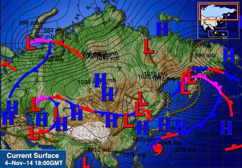
       My country Japan, is located in Asia, apparently Asia is likely to have number of colds day and nights decrease over and time and the number of warm days and nights to increase.(Hijioka 1333-1334) The East Asian and Winter Monsoon circulation have been getting weaker and weaker through out the years(Hijioka 1333-1334). Since the 1920s the East Asian summer monsoon started to weaken in the sea level gradient(Hijioka 1333-1334). The ratio of rainfall for the wet to dry seasons have increased between 1955 to 2005 in Southeast Asia(Hijioka 1333-1334). In the East, South, and Southeast Asia, it is more likely in the future that the precipitation related to the monsoon are going to increase(Hijioka 1333-1334). The subtropical and topical oceans will warm and the warming signals will show(Hijioka 1333-1334). In 1960's, China area have been having weaker seasonal and annual mean winds (Hijioka 1333-1334.) These section is telling us, how the climate is change globally. Asia's season and weather is getting mess up because of these climate change. The seasonal Asian Monsoon, which is a famous phenomenon, is getting weaker but is spreading. Just these small factors are changing around the world.

        The Phenology and growth rates are a huge impact that sounds interesting to me. The East Asia 's plants are measured by the "greenness"(Hijioka 1339). Since 1980s, the season spring has been having early leafing days(Hijioka 1339). The spring flowering early and fall senescence falling behind has been written down (Hijioka 1339). This showing the that the season days have got all messed up, and maybe in the future summer days will have fall/autumn events happen instead. The spring growth have gone ahead in the 90s but the trend is different between areas and the data (Yu et al., 2010, 2012; Dong et al., 2013; Jin et al., 2013; Shen et al., 2013; Yu, Z. et al., 2013a; Zhang, G. et al., 2013; Zhang, L. et al., 2013). Getting closing to the spring greening and longer growing season are known to have humid temperate and boreal areas (Hijoka 1340).  I chose this impact because the seasons and the growth rates tell us how the climate changing slowly around us. It doesn't destroy any wildlife or plants, but it can affect people later on in the future because the season are slowly getting more earlier and earlier. Do I care about the economics? Of course I do. There is nothing dangerous about this impact but maybe later on, it could be a risk. The animals and nature are affect by this impact because it decides the seasons greening and growth rates.

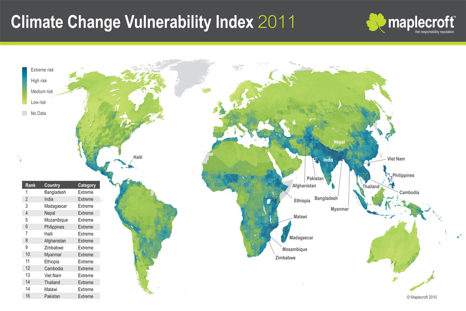
http://static.guim.co.uk/sys-images/Environment/Pix/columnists/2010/10/21/1287657605700/Climate-Change-Vulnerabil-008.jpg
http://scienceofdoom.files.wordpress.com/2010/01/ipcc-2007-temperature-150yrs.png

https://c1.staticflickr.com/3/2634/3719017725_8c14405266.jpg


Thursday, November 20, 2014

Severe Weather in Japan

 A tornadoes are formed by having a rotating body of air (which is a called a vertical sheer) at the ground. Then the horizontal rotating air lifted off the floor from the updraft of the thunderstorm. After, the Mesocyclone is finally developed form the updraft of the thunderstorm. A mesocyclone is a vertical cylinder of rotating air, which is normally 3 to 10 kilometers. In United States the direction the tornadoes usually travels west to east. This is the dominant direction in the United states because the Westerlies blows the Thunderstorm clouds west to east. Tornadoes do happen in Japan, usually spring time. The average number of tornadoes observed in the United States per year is 1253. Website: http://www.ncdc.noaa.gov/climate-information/extreme-events/us-tornado-climatology . The average number of tornadoes observed in Japan per year is 20. Website:  http://www.islandnet. com/~see/weather/almanac/arc2007/alm07jun.htm .
http://www.windows2universe.org/earth/images/tornado_agri_map.jpg


Tornadoes are increasing more and more through out the years. The reason for that must be that, the Earth is getting hotter and hotter, maybe because of c=global warming. Which could be causing the air to get hotter. So more vertical wind sheer are made, the thunderstorm's updraft to make the tornadoes.


The three main requirements for hurricane formations are warm ocean temperatures (anything greater than 80 degrees F), deep warm ocean layer (200 meters in depth), and a Coriolis is needed. Japan can satisfies the deep warm ocean layer and the Coriolis. And the warm ocean temperatures will does not satisfy the requirement. The tradewinds blows northeast to southeast , and it creates tropical wave and troughs. After that, the convergence convection happens which is went converging air rises and cool, The clouds from behind the trough, and the tropical waves grow in to hurricanes.
http://www.mhschool.com/socialstudies/2007/hurricanekatrina/images_hurricaneKatrina/MMh-hurricane-diagram-m.jpg


In the United Sates, the general path do hurricanes usually travels from southern Atlantis ocean  to the Gulf of Mexico. Its the dominant direction that hurricanes travel to United States because of the westerlies and tradewinds blow the hurricanes those directions. Hurricanes happens in Japan but they are called Typhoons. The average number of hurricanes that hit the United States per year is 5. Website:http://www.ems.psu.edu/~nese/ch11sec2.htm. The average number of typhoons that hit  Japan per year is one. Only 28 typhoons have hit Japan so far, that were accorded. Website:  http://www.japantimes.co.jp/life/2013/11/03/language/this-is-the-year-of-the typhoon/#. VG7sofnF9qU.

Tuesday, November 4, 2014

Daily Weather in Japan

           My Country's Capital City is Tokyo. My 3-days forecast will cover the following days of  November 5th, November 6th, and November 7th.   On the November 5th, the highest forecast is 65 degrees F and the lowest forecast is 55 degrees F. The precipitation percent is 17 percent. The forecasted high for my second day is 63 degrees F and the forecasted low is 59 degrees F. The precipitation percent is 77 percent. The highest forecast on November 7th is 63 degrees F and the lowest forecast is 57 degrees F. The precipitation percent is 33 percent. The average pressure over the three day period is 30 inches. The pressure decreased then increased over the three day period. The average wind speed over the three day period is 16 mph. The wind speed decreased over the three day period.

           In Tokyo , there is clouds around the area. They are very close, actually they are right above the Tokyo. They is grey and blue clouds around the area so there is both low warm clouds and high cold clouds in the area, but there is mostly high cold clouds. There isn't any precipitation in my region right now. There isn't light precipitation, medium precipitation or heavy precipitation. Tokyo has mostly grey on the ground surface.  So there is mostly cities in Tokyo rather than green forest. Tokyo has a bay that is called Tokyo Bay. Also there is few rivers in Tokyo for example there is Tama River.
http://www.intellicast.com/Global/Surface.aspx?location=CHXX0441

http://www.intellicast.com/Global/Surface.aspx?location=CHXX0441

        There is High pressures and Low pressures on both regional and large map. There is cold fronts which is located in the Northwest. The warm fronts are also located in the Northwest. The stationary front is located Southeast. Actually on the larger map, there were some occluded fronts which is when the cold fronts and warm fronts becomes one.


Wednesday, October 29, 2014

Global and Local Winds in Japan

            The latitude and longitude of Japan is 35.6833 degrees N, 139.7667 degrees E. The Hemisphere that Japan is located in is mostly the Northern Hemisphere and some of Eastern Hemisphere. In which of the three "atmospheric cell" that Japan reside is the Ferrell Cell. The wind belt that Japan reside on this the westerlies. The direction the wind (westerlies) actually blow from horse latitudes to poles. Japan is located near a main pressure belt. It located Sanbagawa belt, its a world's classical high pressure belt. Japan is located near the horse latitudes. The horse latitudes is located in 25 degrees N to 30 degrees N and Japan is located 35.6833 degrees N so its very close to the horse latitudes.


https://lh3.googleusercontent.com/-DP02PCjGb5M/U325NNPhcnI/AAAAAAAAFHg/E13xkmXLZG0/s786/jetstream%2520global%2520may%252021st%25202014.png


             Japan is located in the Ferrell Cell, which is the coordinates 30 degrees N to 60 degrees N. The Ferrell Cell has a net surface that flows toward the poles. The poles are very close to Japan and the polar fronts too. The winds that are located in this cell is called the westerlies. The westerlies are bend to the west because of the Coriolis force. There's many cyclones located in this cell. And the westerlies are the ones that directed them. The wind blows east to west, so it has windward winds and the winds are sinking. Japan gets a lot of clouds and precipitation because of the moist location they are located in. Japan has similar weather and climates to United States because it depends where you live in Japan to have cold weather or hot weather, just like United States.

             Japan does have mountains, there's Mount Fuji, Mount Kita, Mount Aino and many more. The five types of breezes that are associated with mountains are mountain breeze, valley breeze, Chinook winds, Santa Ana winds, and Katabatic winds. My country can experiences mountain breeze and valley breeze. Mountain breeze is the raditional cooling of the valley walls and it happens during night time. The valley breeze is when the sun warms the valley walls and it happens during day time.
My country does have a coastline, its pretty much surrounded by water. The two breezes that associates with the coastlines are land breeze and seas breeze. Yes, Japan can experience both of these breezes.
https://blogger.googleusercontent.com/img/b/R29vZ2xl/AVvXsEjOL3qZ7C4BCtU32HB0oeYrLDLByU36AN213eEsQUkp57Pqem3ee-Tx9nwAS7T46JDvX6bbqy4T8RYhzzZm-FY6uTjoi0WRVbl1XMZHdnUCvEKrEYSEv6tTTY8h5vJFmEi_PHIq8r90_Rts/s1600/Japan-Mt.Fuji_.jpg

Friday, October 10, 2014

Typical Weather and Tourism in Japan

The days that Winter Solstice occur in Japan (Tokyo) is December 22nd. The average maximum temperature of December is 11 Celsius. The average minimum temperature of December is 4 Celsius. The type of precipitation that is most likely to occur during the Winter Solstice is rain, snow, glaze, and sleet. Depending on your location in Japan, you would get different precipitations in that area. For example, Nagasaki would have more rain as a precipitation than snow. It just depends on the location.

The Summer Solstice occur in Japan (Tokyo) on June 21st. The average maximum temperature of June is 24 Celsius. The average minimum temperature of June is 18 Celsius. The type of precipitation that is most likely to occur during the Summer Solstice is rain. Actually Japan is known to rain a lot during the months of June and July. The average rainfalls on the months of June and July is 20 days. Which is more than half the months that the Japanese people should be carrying umbrellas.

The day that Spring Equinox in Japan (Tokyo) occur is March 21st. The average maximum temperature of March is 12 Celsius. The average minimum temperature of March is 5 Celsius. The types of precipitation that is most likely to occur during the Spring Equinox is rain. The average rainfall in March isn't as high as June and July. But, the average rainfall is still pretty high, it 17 days in the month.

The Autumnal Solstice occur in Japan (Tokyo) on September 23rd. The average maximum temperature of September is 26 Celsius. The average minimum temperature of September is 20 Celsius. The types of precipitation that is most likely to occur during the Autumnal Equinox is rain. September has the same average rainfall as the months of June and July. The months, June and July has the highest average rainfall. Which means September also has one of the highest average rainfall.

I would recommend you to traveling to Japan during the spring season which is March 21st, the start of Spring Equinox. This month doesn't rain as much as other so you can travel around without an umbrella most of the time. The types of activities you could do in Japan during the spring season. You can visit the Japanese's garden since its blooming season, so you can see the beautiful flowers like the Japanese cherry blossom trees. And recently they opened Harry Potter World in Japan, which is a huge hit and you can purchase your own wand! During spring season, there isn't any potential weather hazards. The weather is not too hot but not too cold. It's just the perfect mix of cool air and beautiful flowers surrounding you everywhere. The only bad thing, it might rain but you can't really control that if it does happen.


Always something different to do! 

Friday, October 3, 2014

Temperature Controls in the city of Tokyo in Japan

           
http://www.drben.net/publishImages/Koreas_Report~Sources~Korea_Maps~Historic~1945~Map-Japan-Korea-1945-01~~element1972.jpg

 Japan is located on the east coast of Asia. It lies between the Sea of Japan and North Pacific Ocean. 

The neighbor countries are North Korea, South Korea, China, and Russia. Its 277,955 sq kilometer long in longitude. The capital city of my country is Tokyo. The latitude and longitude of capital city is 35.6895° N, 139.6917° E. The warmest month in my city is August with an average monthly temperature of 79 F. The coldest month in my city is January with an average monthly temperature of 41 F. Based on the information above the annual range of temperature for my city is 38 F. The website where I found this information:  http://www.holiday-weather.com/tokyo/averages/. One of the temperature controls that impacts Tokyo is the  geographic position. Tokyo is on the east coast and is located  middle of Japan. Tokyo has a subtropical weather, it does has season but some seasons are not strongly impacted then others. If the city was in the northern half of Japan, it would experience extremely cold weather but Tokyo is located the bottom half of japan so the winter aren't as strong like the ones in the city of Obihiro.
             Honestly, I believe that all of the temperature controls does impact Tokyo. The ocean currents caused by wind to reaction between the atmosphere and the ocean. For example, the ocean current that deals with Japan is Kuroshiro Current. Kuroshiro Current is the northern flowing current on the west side of the Japan.  The altitude, geographic position, and Albedo also helps with Tokyo's temperature. Before I stated the altitude and geographic position's reasons. With me telling you this, I believe there  isn't a  temperature controls we discussed in class that doesn't impact the bright city of Tokyo.
             Japan's weather and climate varies from north to south just like United States. Obihiro gets extremely harsh winter because it is located in the northern area of Japan. Not the same situation for Kagoshima, which does still get winter for not as harsh as Obihiro. It gets subtropical weather, because it located on the southern part of Japan. This shows that the altitude and the geographic positions is really important in controlling the weather. December to February is the cold months which brings lots of snow and bizarre. Then June and July is the rainy and hot months, those months gets droughts and typhoons. Japan is just a country which has similar weather and climate as any state in United States. Some states of United States has a hotter summer than others states, just like Japan.
               Since Tokyo's geographic position and altitude position shows us that Tokyo has subtropical weather, which I mention before. With this information, I can predict what type of weather it should have over the years. Springs and summers are very hot compare to other places in Japan but their falls and winters are cold but not compare to the other places (especially the northern half ), which gets extremely cold. June is the raining month for Japan which includes the capital city Tokyo. The city is quite humid, so it gets pretty hot when the sunny months come along, which is around August.
                

Wednesday, September 10, 2014

About Me

My name is Audrey Uhl and I am a meteorology major at the University of Hawaii at Manoa. I am creating this blog for a course called "Introduction of Meteorology" (MET 101). This blog is going to be about the Japan's climate and weather, which is located in Asia. This is going to be my first time blogging. Wish me luck!